|
AIRPORTS
Within Nepalese territory there are 50 airports which includes
fully operating, unmanned and under construction airports.
These airports can be categorized as follows.
a. International Airport
b. Terai/Low land Airport
c. Remote/Hilly Airports
d. Remote/High altitude Airports
Click on the areas
(map) below for details
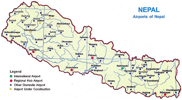
a. International Airport :
1. Tribhuvan international airport :
Air traffic control services is provided in this airport to
all aircrafts in flight by air traffic controllers. There are
various air traffic control units as aerodrome control center,
approach control center, area control center. Airport consists
of metallic runway of length 3050m and width 50m , easily
accessible about 15mins drive from the city center by road.
International airport situated at the height of 1338m. Radar
facility is also available at approach control center where
radar control service is provided for transponder equipped
instrumental departing and arriving aircrafts. Approach radar,
approach non-radar, Area and aerodrome control ratings are
done and proficiency is maintained for rated positions by
periodical checks and renewals. This is a single international
and busiest airport within Nepalese FIR.
b. Terai/Low land Airport
2. Biratnagar Airport : Aerodrome
control service and approach control service is provided by
air traffic controllers. The runway is paved with length of
1524m and width 30m. Airport is easily accessible by the road
network. Regional hub airport at the altitude of 72m. Approach
and aerodrome control ratings are done and proficiency is
maintained for rated positions by periodical checks and
renewals.
3 Bhairahawa Airport : Aerodrome
control service and approach control service provided by air
traffic controllers. Runway paved with length of 1524m and
width 30m. Airport accessible by the road network Regional hub
airport situated at the altitude of 109m. Approach and
aerodrome control ratings are done and proficiency is
maintained for rated positions by periodical checks and
renewals.
4. Bharatpur : Aerodrome control
service provided by the air traffic controllers and
assistants. Gravel/Grass runway with length of 1158m and width
30m , airport accessible by the road network. Airport situated
at the height of 183m.
5. Chandragadhi Airport :
Aerodrome flight information service provided by the air
traffic controllers and assistants. Runway paved with length
of 1524m and width 36m , airport accessible by the road
network. Airport situated at height of 91m.
6. Dhangadhi Airport : Aerodrome
flight information service provided by the air traffic
controllers and assistants. Grass Runway with length of 1524m
and width 30m , airport accessible by the road network.
Airport situated at height of 210m.
7. Janakpur Airport : Aerodrome
control service provided by the air traffic controllers .
Runway paved with length of 1066m and width 30m , airport
accessible by the road network. Airport situated at height of
78m.
8. Mahendranagar Airport :
Aerodrome flight information service provided by the air
traffic controllers and assistants. Grass runway with length
of 884m and width 30m , airport accessible by the road
network. Airport situated at height of 198m.
9. Meghauli : Aerodrome flight
information service provided by the assistants. Grass runway
with length of 1067m and width 46m , airport accessible by
road network. Airport situated at the height of 183m.
10. Nepalgunj Airport : Aerodrome
control and approach control service provided by the air
traffic controllers . Runway paved with length of 1524m and
width 30m , airport accessible by the road network. Regional
hub airport situated at the height of 165m. Approach and
aerodrome control ratings are done and proficiency is
maintained for rated positions by periodical checks and
renewals.
11. Rajbiraj Airport : Aerodrome
flight information service provided by the air traffic
controllers and assistants. Grass runway with length of 1280m
and width 46m , airport accessible by the road network.
Airport situated at the height of 76m.
12. Simara Airport : Aerodrome
control service provided by the air traffic controllers .
Runway paved with length of 1219m and width 46m , airport
accessible by the road network. Airport situated at the height
of 137m.Approach and aerodrome control ratings are done and
proficiency is maintained for rated positions by periodical
checks and renewals.
13. Tikapur Airport : Aerodrome
flight information service provided by the air traffic
controllers and assistants. Grass runway with length of 549m
and width 30m , airport accessible by the road network.
Airport situated at the height of 243m.
c. Remote/ Hilly Airports
14. Balewa : Aerodrome flight
information service provided by the assistants but currently
unmanned due no flight movements. Grass runway with length of
610m and width 30m , airport accessible by the road network.
Airport situated at the height of 1012m.
15. Bhojpur : Aerodrome flight
information service provided by the assistants. Grass runway
with length of 533m and width 30m , airport accessible by foot
trails only. Airport situated at the height of 1067m.
16. Baitadi : Aerodrome flight
information service provided by the assistants. Grass runway
with length of 500m and width 30m , airport accessible by the
road network. Airport situated at the height of 1280m.
17. Bajhang : Aerodrome flight
information service provided by the assistants. Grass runway
with length of 640m and width 30m , airport accessible by foot
trails only. Airport situated at the height of 1250m.
18. Bajura : Aerodrome flight
information service provided by assistants. Grass runway with
length of 573m and width 30m , airport accessible by the road
network. Airport situated at the height of 1311m.
19. Chaurjahari : Aerodrome
flight information service provided by the assistants. Grass
runway with length of 488m and width 30m , airport accessible
by foot trails and horse track only. Airport situated at the
height of 762m.
20. Doti : Aerodrome flight
information service provided by the assistants. Grass runway
with length of 427m and width 30m , airport accessible by foot
trails and horse track only. Airport situated at the height of
640m.
21. Darchula : Aerodrome flight
information service provided by the assistants. Grass runway
with length of 590m and width 30m , airport accessible by road
network. Airport situated at the height of 650m.
22. Dang : Aerodrome flight
information service provided by the assistants . Grass runway
with length of 832m and width 36m , airport accessible by road
network. Airport situated at the height of 640m.
23. Gorkha : Aerodrome flight
information service provided by the assistants but currently
unmanned due no flight movements. Grass runway with length of
1097m and width 46m , airport accessible by road network.
Airport situated at the height of 457m.
24. Jiri : Aerodrome flight
information service provided by the assistants currently
unmanned due no flight movements. Grass runway with length of
366m and width 18m , airport accessible by road network.
Airport situated at the height of 1830m.
25. Kalikot : Airport under
construction accessible by foot trail and horse track only.
26. Kamalbazaar : Airport under
construction accessible by foot trail and horse track only.
27. Kangeldanda : Airport under
construction accessible by foot trail and horse track only.
28. Lamidanda : Aerodrome flight
information service provided by the assistants. Grass runway
with length of 518m and width 30m , airport accessible by foot
trails and horse track only. Airport situated at the height of
1250m.
29. Masinechaur : Airport under
construction accessible by foot trail and horse track only.
30. Pokhara : Aerodrome control
service provided by the air traffic controllers. Runway paved
with length of 1433m and width 30m , airport accessible by
road network. Regional hub airport Airport situated at the
height of 827m.Approach and aerodrome control ratings are done
and proficiency is maintained for rated positions by
periodical checks and renewals.
31. Rolpa : Aerodrome flight
information service provided by the assistants. Grass Runway
with length of 457m and width 30m , airport accessible by road
network. Airport situated at the height of 1250m.
32. Rumjatar : Aerodrome flight
information service provided by the assistants. Grass Runway
with length of 549m and width 30m , airport accessible by foot
trails and horse track only. Airport situated at the height of
1524m.
33. Ramechaap : Aerodrome flight
information service provided by the assistants. Grass Runway
with length of 518m and width 30m , airport accessible by foot
trails and horse track only. Airport situated at the height of
474m.
34. Sanfebagar : Aerodrome flight
information service provided by the assistants. Grass Runway
with length of 427m and width 30m , airport accessible by road
network. Airport situated at the height of 695m.
35. Salley : Aerodrome flight
information service provided by the assistants. Grass Runway ,
airport accessible by foot trail and horse track only.
36. Surkhet : Aerodrome flight
information service provided by the assistants. Grass Runway
with length of 1036m and width 30m , airport accessible by
road network. Airport situated at the height of 732m.
37. Tumlingtar : Aerodrome flight
information service provided by air traffic controllers and
the assistants. Grass Runway with length of 1219m and width
46m , airport accessible by foot trail and horse track.
Airport situated at the height of 518m.
38.Thamkharka : Airport under
construction accessible by foot trail and horse track.
d. Remote/high altitude
39. Dhorpatan : Aerodrome flight
information service provided by the assistants. Grass runway
with length of 366m and width 30m , airport accessible by foot
trail and horse track only. Airport situated at the height of
2728m.
40. Dolpa : Aerodrome flight
information service provided by the assistants. Grass Runway
with length of 457m and width 30m , airport accessible by foot
trail and horse track only. Airport situated at the height of
2500m.
41. Jomsom : Aerodrome flight
information service provided by the air traffic controllers.
Runway paved with length of 610m and width 30m , airport
accessible by foot trail and horse track only. Airport
situated at the height of 2682m.
42. Jumla : Aerodrome flight
information service provided by air traffic controllers and
assistants. Runway paved with length of 670m and width 30m ,
airport accessible by foot trail and horse track only. Airport
situated at the height of 2591m.
43. Lukla : Aerodrome flight
information service provided by the air traffic controllers.
Runway paved with length of 488m and width 30m , airport
accessible by foot trail and horse track only. Airport
situated at the height of 2591m.
44. Langtang : Aerodrome flight
information service provided but unmanned due no flight
movements. Grass Runway with length of 421m and width 30m ,
airport accessible by foot trail and horse track only. Airport
situated at the height of 3658m.
45. Mugu : Aerodrome flight
information service provided by the assistants. Grass Runway
,airport accessible by foot trail and horse track only.
46. Manang : Aerodrome flight
information service provided by the assistants. Grass Runway
with length of 610m and width 30m , airport accessible by foot
trail and horse track only. Airport situated at the height of
3353m.
47. Syangboche : Aerodrome flight
information service provided but unmanned due no flight
movements.. Grass Runway with length of 405m and width 30m ,
airport accessible by foot trail and horse track only. Airport
situated at the height of 3748m.
48. Simikot : Aerodrome flight
information service provided by the assistants. Grass Runway
with length of 549m and width 18m , airport accessible by foot
trail and horse track only. Airport situated at the height of
2818m.
49. Taplejung : Aerodrome flight
information service provided by the assistants. Grass/gravel
runway with length of 594m and width 30m , airport accessible
by foot trail and horse track only. Airport situated at the
height of 2377m.
50. Phaplu : Aerodrome flight
information service provided by the assistants. Grass Runway
with length of 670m and width 30m , airport accessible by foot
trail and horse track only. Airport situated at the height of
2431m.
Other
Links -
AIR
TRAFFIC CONTROL PROFESSION
EXECUTIVE
COMMITTEE
PHOTOGRAPHS
AIRPORTS
|
|